Jutland
Peninsula forming continental Denmark and part of northern Germany.

John Buchan · Public domain
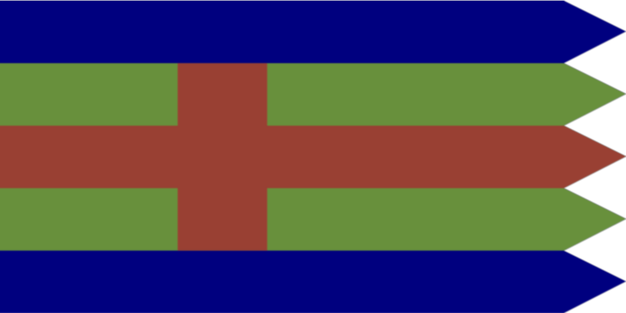
Jutland is a peninsula in Northern Europe that forms the continental portion of Denmark and part of northern Germany (Schleswig-Holstein). It stretches from the Grenen spit in the north to the confluence of the Elbe and the Sude in the southeast. The peninsula is historically significant as the cultural-geographical region of the Jutes and Cimbri, and its southern border river, the Eider, once marked the boundary between the Kingdom of Denmark and the Holy Roman Empire/Germany.
- Longest river
- Gudenå
Lore & Background
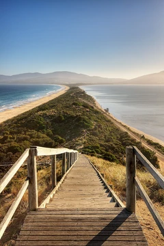
Jutland's geography is flat, with comparatively steep hills in the east and a barely noticeable ridge through the center. West Jutland is characterized by open lands, heaths, plains, and peat bogs, while East Jutland is more fertile with lakes and lush forests. The southwestern coast features the Wadden Sea, a large international coastal region stretching through Denmark, Germany, and the Netherlands. The peninsula's longest river is the Gudenå, which flows entirely within Jutland, while the Eider is a notable river in the south.
Reader's Guide
Jutland's significance lies in its role as a cultural and geographical bridge between Scandinavia and continental Europe. The peninsula is known by several names, including Jylland in Danish and Jütland in German, and anciently as the Cimbric Peninsula. The Kiel Canal, the world's busiest artificial waterway, crosses the peninsula in the south, allowing ships to avoid navigating around the entire peninsula to reach the Baltic. Jutland is connected to Funen by the Old and New Little Belt Bridge, and Funen in turn is connected to Zealand and Copenhagen by the Great Belt Bridge. The region includes subregions such as Lauenburg, Hamburg, Holstein, Southern Schleswig, and Southern Jutland, each with distinct historical and cultural characteristics. The Danevirke, a system of Danish fortifications, runs through Southern Schleswig, and the former Viking town of Hedeby lies at its Baltic end.
Did You Know?
- Jutland is also known as the Cimbric Peninsula, derived from the Cimbri.
- The Kiel Canal, crossing the peninsula in the south, is one of the world's busiest artificial waterways, though the Panama and Suez Canals generally hold the top spots depending on the metric.
- The Gudenå is the longest river on the Jutland peninsula.
- The Wadden Sea, a unique coastal region, stretches along the southwestern coast through Denmark, Germany, and the Netherlands.
Physical Landscape & Terrain
Jutland's terrain is predominantly flat, with only a barely perceptible ridge threading through its center and comparatively steeper hills concentrated along the eastern edge. This gentle topography creates a striking internal contrast: the western half opens into vast heaths, plains, peat bogs, and unbroken stretches of open land, while the eastern half rewards with fertile soil, scattered lakes, and dense, lush forests. The southwestern shoreline gives way to the Wadden Sea, a vast international coastal zone shared across Denmark, Germany, and the Netherlands. Waterways thread through the landscape in unexpected directions—the Eider, the peninsula's longest river, originates near the Baltic yet flows toward the North Sea because a glacial moraine redirects its course, while the Gudenå holds the title of Denmark's longest river. The overall effect is a land of subtle gradients rather than dramatic peaks, where water and lowland define the character of the place.
A Peninsula Divided by Language and History
The word Jutland carries different meanings depending on which side of the border you stand. In Danish usage, Jylland can encompass the entire peninsula from the Grenen spit down to the Elbe, or it can refer only to the Danish portion stretching to the Danish-German border. In German, however, the full peninsula is called the Kimbrische or Jütische Halbinsel, while Jütland is reserved strictly for the cultural-geographical region. Southern Schleswig, lying between the Eider and the modern border, is sometimes folded into the cultural concept of Jutland, while Holstein, the former duchy of Lauenburg, and the cities of Hamburg and Lübeck belong to the physical peninsula but sit outside its traditional cultural identity.
Names Carved by Ancient Peoples
The peninsula bears a remarkable palimpsest of names, each a fossil of a different era's encounter with the land. In Danish it is Jylland, in German Jütland, and in Old English Ēota land—all three tracing back to the Jutes, the Germanic tribe who settled here in antiquity. A far older layer survives in the Latin Cimbricus Chersonesus and its descendants in Danish and German, the Kimbrische Halbinsel, named for the Cimbri, a people who swept through the region in the second century BCE. The Danish equivalent, den Kimbriske Halvø or den Jyske Halvø, and the German Kimbrische Halbinsel or Jütische Halbinsel, preserve both ancient references side by side. This dual naming—Jutes and Cimbri—means that even the most basic question of what to call this place already layers two millennia of migration, conquest, and memory into a single geographic label.
Waterways, Bridges, and the Art of Crossing
Jutland is a land defined as much by the water surrounding it as by the ground beneath. Its western and northern coasts face the North Sea and the Skagerrak, while the northeast and southeast look out over the Kattegat and the Baltic Sea—the latter section locally called Bælthavet in Danish and Beltsee in German, a name born from the Great, Little, and Fehmarn belts. To spare ships the long detour around the entire peninsula, the Kiel Canal was cut through the southern tip, and it now ranks as the world's busiest artificial waterway. The Elbe-Lübeck Canal offers a second inland route, linking the Elbe at Lauenburg to the Baltic at Lübeck. For land traffic, the Old and New Little Belt Bridges tie Jutland to Funen, and the Great Belt Bridge carries travelers onward to Zealand and Copenhagen. Together these crossings transform a peninsula into a crossroads.
Gallery
Frequently Asked Questions
Who is Jutland?
Jutland is a Northern European peninsula that constitutes the mainland of Denmark and extends into northern Germany's Schleswig-Holstein region. It sits between the North Sea and the Baltic Sea.
What role does Jutland play geographically?
It acts as the primary landmass linking the Scandinavian Peninsula to the broader European continent. It anchors both Denmark's continental territory and the northern German coastline.
Where does Jutland begin and end?
The peninsula starts at the Grenen spit in the north and stretches southeastward to the meeting point of the Elbe and Sude rivers. That southeastern confluence marks its final boundary.
Why is Jutland historically significant?
The region was the ancestral homeland of the Jutes and Cimbri peoples. The Eider River, which crosses its southern portion, once served as the political border between the Kingdom of Denmark and the Holy Roman Empire.
What is Jutland's longest river?
The Gudenå holds that title, flowing through the central Danish portion of the peninsula. It is the most prominent waterway in the region's interior landscape.
More in Peninsulas And Isthmuses 1-24
Spotted an error? Know more?
This is a living reference — every entry is fact-audited, and reader corrections feed straight into our audit queue. Suggest an edit · See this site's audit record