Labrador Peninsula
A large eastern Canadian peninsula with diverse geography and indigenous history.

via Wikipedia: Peninsula · see source
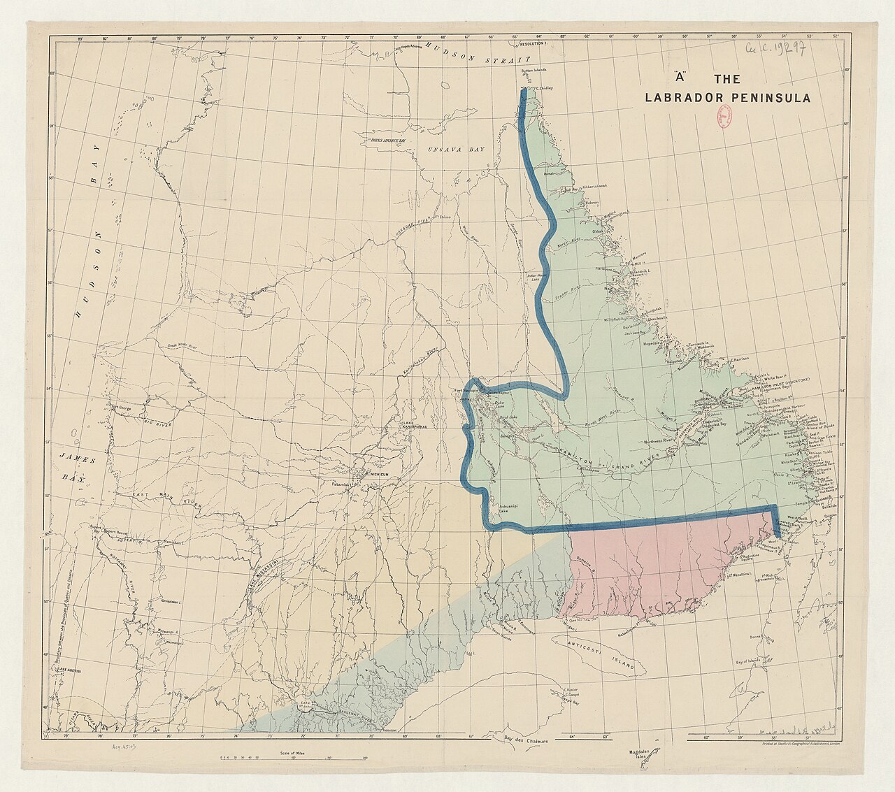
The Labrador Peninsula is a large peninsula in eastern Canada. Lawrence to the southeast.
- area
- 1,400,000 km² (541,000 sq mi)
- highest_point
- Mount Caubvick, 1,652 m (5,420 ft)
- longest_river
- La Grande River, 900 km (560 mi)
- largest_natural_lake
- Lake Mistassini
- largest_water_body
- Smallwood Reservoir
- northernmost_point
- Cape Wolstenholme
Lore & Background
Prior to European colonization, the peninsula was inhabited chiefly by Cree and Inuit peoples. Inuit homelands included Nunavik in northern Quebec, Nunatsiavut in northern Labrador, and NunatuKavut in southern Labrador.
Reader's Guide
The Labrador Peninsula is significant for its vast size and geographic diversity, encompassing plateaus, mountain ranges, and numerous lakes and rivers. The peninsula's hydrology has been heavily shaped by hydroelectric development, with most large freshwater lakes now being reservoirs.
Did You Know?
- The word 'peninsula' comes from Latin paeninsula, meaning 'almost island'.
- The largest peninsula in the world is the Arabian Peninsula.
- Peninsulas exist on every continent.
- The Isthmus of Corinth connects the Peloponnese peninsula to Central Greece.
- The Malay Peninsula played an important role in east-west trade.
Naming and Defining the Landform
The very name we use to describe this landform carries a poetic origin. Rooted in the Latin word paeninsula, it combines paene, meaning 'almost,' with insula, meaning 'island'—essentially capturing the idea of a place that is nearly, but not quite, an island. This term made its way into English during the sixteenth century and has stuck ever since. In practical terms, a peninsula is a stretch of land encircled by water on the majority of its sides while remaining tethered to the mainland on just one. Importantly, the surrounding water does not have to be an ocean or a sea; a particularly tight river bend or the land wedged between two rivers can qualify. The New Barbadoes Neck in New Jersey is one such example where river geometry creates a peninsular shape. The link between the peninsula and the larger landmass may take the form of an isthmus, as the Isthmus of Corinth does for the Peloponnese in Greece. While peninsulas appear on every continent, the Arabian Peninsula holds the distinction of being the largest in the world.
Geological Birth: How Peninsulas Take Shape
No single force is responsible for creating a peninsula. Continental drift, glacial activity, volcanic eruptions, shifting sea levels, and sediment carried by rivers can each play a role, and in many cases several of these processes combine. Florida, for instance, owes its outline to a blend of continental drift, marine sediment, and marine transgressions acting together. When glaciers are the sculptor, three distinct mechanisms come into play. Erosion carves basins where softer rock gives way while harder rock resists, as seen in the Keweenaw Peninsula. Meltwater, dammed by glacial moraines, can pool around a landmass to ring it with water. Deposition, meanwhile, piles up glacial drift into hills of sedimentary rock that, if they sit near water while still attached to the mainland, become peninsulas—Cape Cod formed this way roughly twenty-three thousand years ago. Volcanic peninsulas emerge when magma meets water, particularly in shallow settings, as with the Alaskan Peninsula. Plate tectonics adds further variety: divergent boundaries can produce rift peninsulas like the Arabian Peninsula, while convergent boundaries shape landforms such as Gibraltar and the Indian subcontinent. River sedimentation at delta mouths offers yet another pathway.
Strategic Value Through the Ages
Long before modern maps existed, peninsulas served as natural refuges for early humans and Neanderthals. Their geography offered a practical survival advantage: from a single vantage point, inhabitants could hunt both terrestrial and marine animals, diversifying their food sources without having to travel far. Beyond prehistory, peninsulas have functioned as natural boundary markers, helping to delineate the borders of nations. Their strategic position—connected to the mainland yet open to water—made them invaluable for trade and commerce. Access through an isthmus allowed goods and people to flow between land and sea routes with relative ease. The Malay Peninsula stands out as a prime historical example. Situated at the point where the Indian Ocean meets the China Seas, it became a critical node in east-west trade networks, channeling commerce between two vast maritime regions. This combination of defensive shelter, economic opportunity, and geopolitical significance has made peninsulas among the most consequential landforms in human history, shaping settlement patterns, military strategy, and commercial routes across millennia.
A Shifting Shoreline: Vulnerability and Change
A peninsula is not a fixed shape; it breathes with the tides and the climate. Marine transgressions—fluctuations in sea level—can both create peninsulas and reshape existing ones. At higher water levels, a peninsula may effectively become an island, severed from its mainland connection. Even within a single season, wet weather raises water levels and makes the landform appear smaller, while dry periods expose more shoreline and give the impression of a larger expanse. These are temporary shifts, but they illustrate a deeper vulnerability. Looking ahead, sea level rise driven by global warming poses a more permanent threat. Over time, the encroaching water will reduce the size of certain peninsulas, eroding the very connection that defines them as peninsulas rather than islands. This slow reclassification is not merely a cartographic curiosity; it carries implications for borders, ecosystems, and the communities that have built their lives on land that the sea is steadily reclaiming.
Gallery


Frequently Asked Questions
What is the Labrador Peninsula?
It is a massive landmass in eastern Canada, also called the Quebec-Labrador Peninsula, that encompasses the Labrador region of Newfoundland and Labrador along with three Quebec regions: Saguenay–Lac-Saint-Jean, Côte-Nord, and Nord-du-Québec.
How large is the Labrador Peninsula?
The peninsula covers roughly 1.4 million square kilometres (about 541,000 square miles), making it one of the largest peninsulas on the North American continent.
What water bodies surround the Labrador Peninsula?
Hudson Bay borders it to the west, Hudson Strait to the north, the Labrador Sea to the east, and the Strait of Belle Isle together with the Gulf of St. Lawrence to the southeast.
What is the highest point on the Labrador Peninsula?
Mount Caubvick holds that distinction, rising to 1,652 metres (5,420 feet) above sea level.
What are the notable rivers and lakes on the Labrador Peninsula?
La Grande River is the longest at 900 km (560 mi), Lake Mistassini is the largest natural lake, and Smallwood Reservoir is the largest water body overall.
More in Peninsulas And Isthmuses 1-24
Related in Peninsulas And Isthmuses
Links follow this subject's own source article.
Spotted an error? Know more?
This is a living reference — every entry is fact-audited, and reader corrections feed straight into our audit queue. Suggest an edit · See this site's audit record